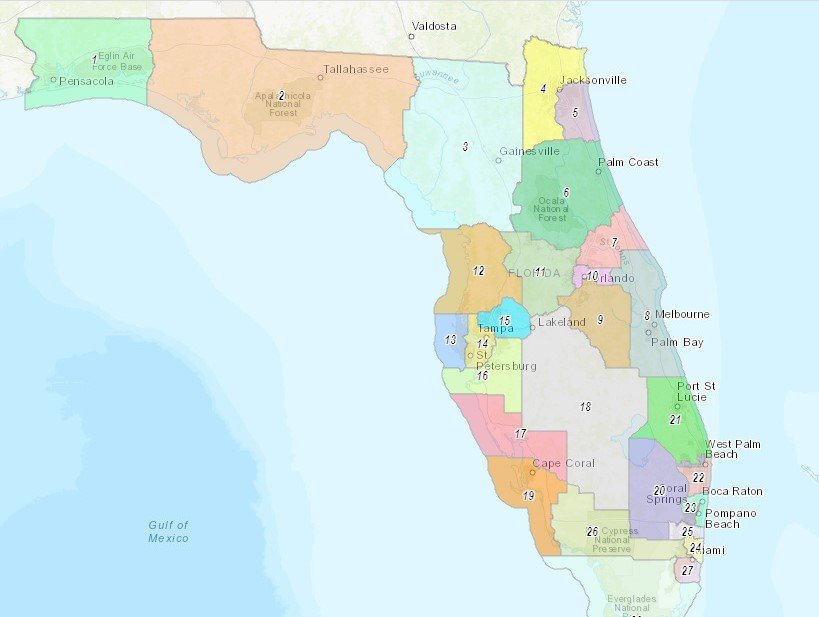
An overview of the congressional district map being proposed by Gov. Ron DeSantis. (All maps: Florida Redistricting)
April 19, 2022 by David Silverberg
Southwest Florida’s congressional district boundaries will experience only minor tweaks under the redistricting map (P000C0109) submitted by Gov. Ron DeSantis (R), which is expected to be enacted under a special legislative session opening today.
A bitter fight has emerged over the disposition of the 5th Congressional District in the panhandle. DeSantis’ map would eliminate the district represented by Rep. Al Lawson (D-5-Fla.) by splitting it into two new districts, 2 and 3, that would likely vote Republican. Democrats are charging that through deliberate gerrymandering in this district and others, DeSantis is trying to wipe out Black representation in Florida. DeSantis has argued that his map is racially neutral.
Also, DeSantis’ map creates 20 Republican districts to Democrats’ eight, ensuring majority Republican representation in Congress for the next decade and favorably positioning him to take Florida’s Electoral College vote if he runs in 2024.
DeSantis vetoed the legislature’s proposed map and instead insisted on passage of his own, a very unusual move given that redistricting is usually in the legislative domain.
An earlier map proposed by DeSantis was very radical in its changes for Southwest Florida, making Lee County its own congressional district and significantly altering the 19th and 25th districts. The new map, submitted by J. Alex Kelly, DeSantis’ deputy chief of staff, is less sweeping for this region.
The DeSantis map, which is likely to be enacted, makes changes to the three districts that constitute Southwest Florida. Some changes are minor, others substantial. All have electoral implications but would remain majority Republican districts.
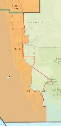
The new 19th

Changes to North Fort Myers (left arrow) and Lehigh Acres (right arrow), both of which move into the 17th District under the DeSantis map. Red lines denote existing district boundaries.
The new 19th
Changes to the 19th District, the coastal area from Cape Coral to Marco Island, are relatively minor and the district keeps its existing number.
The DeSantis map takes a bit of territory out of North Fort Myers and moves it and all of Lehigh Acres into the 17th District. However, unlike other past proposed maps, minority neighborhoods in Fort Myers, like Dunbar, remain within the 19th.
In Collier County, the DeSantis 19th extends the district boundary to Rt. 75 and as far east as Santa Barbara Blvd. between Pine Ridge Rd. and Golden Gate Pkwy., so it now encompasses Village Walk, Livingston Walk, Wyndemere and parts of Golden Gate.
This change would put the home of Rep. Byron Donalds (R-19-Fla.) in the district. Until now he has been representing it while living in Rep. Mario Diaz-Balart’s district.
The Collier County portion of the DeSantis map. Red lines denote existing district boundaries. Blue lines are county borders.
The severed 17th

The DeSantis 17th, which splits the existing district into two. Red lines denote existing boundaries.
The 17th District, currently represented by Rep. Greg Steube (R-17-Fla.) would be substantially reduced and under the DeSantis plan would extend roughly from the Lee County line north to Sarasota and would include sections of North Fort Myers and all of Lehigh Acres.
Much of the 17th’s former interior area—which is very lightly populated—would be transferred to a newly drawn 18th Congressional District, which would include DeSoto, Hardee, Highlands, Okeechobee, Glades and Hendry County and include part of the unincorporated Collier County town of Immokalee.
The renumbered 26th and the splitting of Immokalee

The new 26th District. Red lines denote existing boundaries.
The old 25th District represented by Rep. Mario Diaz-Balart would now be renumbered the 26th and would lose largely unpopulated territory it formerly had in Hendry County. Its center of gravity would still be in the east in the Cuban-American stronghold of Hialeah.
Interestingly, the unincorporated town of Immokalee in Collier County, which was previously in Diaz-Balart’s district, would now be split down the middle between the 26th and the new 18th along North 15th St., and State Road 845.

The town of Immokalee, split down the middle between two congressional districts.
Analysis: The DeSantis implications
For Southwest Florida the most significant change from the DeSantis map is moving Donalds into the 19th District so he doesn’t have to change domiciles and he eliminates a potential electoral vulnerability. Otherwise, the racial, ethnic and partisan makeup of the region stays largely the same and favors the incumbents and the Republican Party.
The division of Immokalee is particularly unfortunate for that low-income community of roughly 20,000 people. The largely Hispanic town of mostly seasonal farmworkers was at the far edge of Diaz-Balart’s district but he would visit it occasionally and he requested $987,000 in federal earmarked funds for sidewalk and drainage improvements. Now, with it divided between districts, it’s likely to be neglected by both congresspeople in whose districts it falls.
The DeSantis map has raised vehement protests from Democrats and charges of racism since it eliminates districts with black representation in the north and around Orlando. Democrats are vowing to challenge it in court, which was exactly the outcome that Sen. Ray Rodrigues (R-27-Fort Myers) worked hard to avoid when he headed the state Senate Redistricting Committee.
Liberty lives in light
© 2022 by David Silverberg